Alt Urgell - Foto: Lutz Meyer

Startseite ReiseCatalunya | Cadi Moixeró

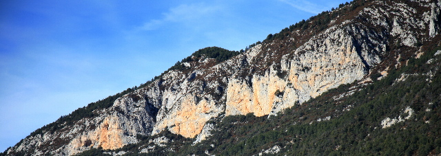
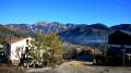
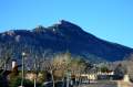
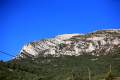
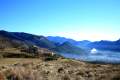
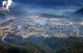
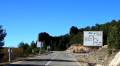
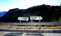
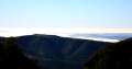
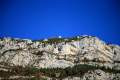
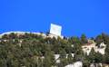
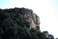
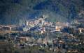
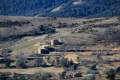
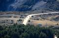
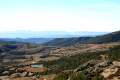
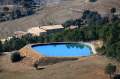
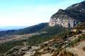
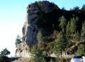
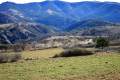
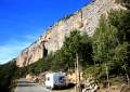
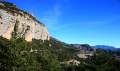
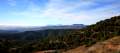
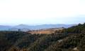
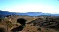
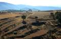
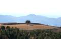
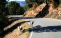
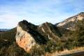
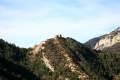
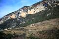
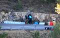
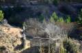
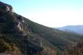
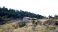
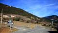
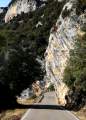
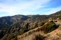
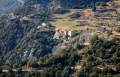
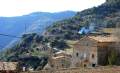
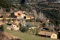
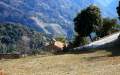
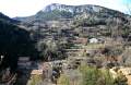
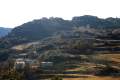
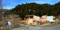
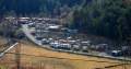
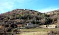
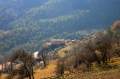
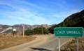
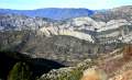
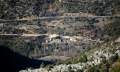
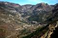
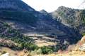
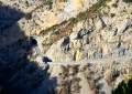
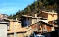
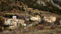
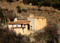
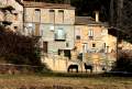
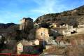
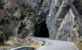
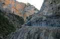
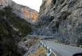
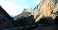
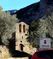
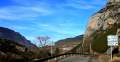
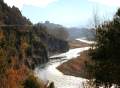
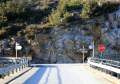
Spanien: Nordspanien: Katalonien Nord: Naturpark Cadi-Moixeró

170km Rundreise durch das westliche Naturschutzgebiet Cadi-Moixeró und die katalonischen Comarques Alt Urgell und Solsonès. 19.-20. Januar 2008

Cadi-Moixeró (El Cadi Teil 2)

Der Naturpark "Parc Natural Cadi-Moixeró" ist ein langgestreckter waagerecht verlaufender Höhenzug wenige Kilometer südlich der Pyrenäen, abgetrennt durch das Tal des Riu Segre. Er besteht aus den beiden nahtlos aneinander gefügten Bergmassiven El Cadi und Serra de Moixeró. Die Gipfel bis 2648m erreichen nicht ganz Pyrenäen-Niveau, doch einzelne Bergzüge ragen mehrere hundert Meter senkrecht in die Höhe.

Teil 2 dieser Tour führt südlich des Cadi Höhenzugs wieder zurück Richtung Westen: Von Sant Llorenc de Morunys (925m) über den Pass Coll de Jou (1480m) in Richtung Coll de Nargó. Gemessen an den nahen Gipfeln des Cadi gemässigte Höhen, doch es wird zum Ende der Etappe auf beiden Seiten der Strasse schroff und eng. So bekommt man als Durchreisender einen starken Eindruck von der Abgeschnittenheit dieser Region. Doch ebenfalls von ihrer Anziehungskraft bei Steilwand-Kletterern und Radrennfahrer Bergetappen-Spezialisten.

Der erste Abschnitt dieser Tour ist hier zu sehen: Von La Seu d'Urgell bis Sant Llorenç

------------

Die Tour hat ab Sant Llorenc ausser Richtung Coll der Nargó zwei alternative Fortsetzungen:

  • Richtung Berga

  • Richtung Solsona

2008 Januar - Fotos Lutz Meyer 

Aktuelle Fotos Katalonien: Catalunya & Iberia Fotos
Weitere Katalonien Foto-Stories finden Sie auf der Startseite Reise/Catalunya.


Sant Llorenç de Morunys, Solsonès - img_3776_84.jpg Coll de Jou - img_3777_85.jpg Skigebiet Port del Comte, Nähe Coll de Jou - img_3793_86.jpg Sant Llorenç de Morunys, Solsonès - img_3784_87.jpg
Sant Llorenç de Morunys, Solsonès - img_3802_88.jpg Coll de Jou - img_3803_89.jpg Coll de Jou - img_3804_90.jpg Panoramablick vom Coll de Jou - img_3806_91.jpg
Port del Comte, Skigebiet, am Coll de Jou - img_3816_92.jpg Werbetafel (leer), Skigebiet Port del Comte, Coll de Jou - img_3825_93.jpg Creu del Codó am Coll de Jou -  img_3828_94.jpg Sant Llorenç de Morunys, Solsonès - img_3829_95.jpg
Sant Llorenç de Morunys, Solsonès - img_3830_96.jpg Blick von Coll de Jou, Solsonès - img_3841_97.jpg Blick von Coll de Jou, Solsonès - img_3845_98.jpg Blick Richtung West von Coll de Jou, Solsonès - img_3847_99.jpg
Blick von Coll de Jou, Solsonès - img_3842_100.jpg Blick von Coll de Jou, Solsonès - img_3846_101.jpg Blick von Coll de Jou, Solsonès - img_3809_102.jpg Strecke Coll de Jou - Cambrils, Solsonès - img_3852_103.jpg
Strecke Coll de Jou - Cambrils, Solsonès - img_3856_104.jpg Blick zurück Coll de Jou - img_3858_105.jpg Strecke Coll de Jou - Cambrils, Solsonès - img_3862_106.jpg Strecke Coll de Jou - Cambrils, Solsonès - img_3860_107.jpg
Strecke Coll de Jou - Cambrils, Solsonès - img_3866_108.jpg Landwirtschaft Strecke Coll de Jou - Cambrils, Solsonès - img_3867_109.jpg Landwirtschaft Strecke Coll de Jou - Cambrils, Solsonès - img_3872_110.jpg Schafherde Strecke Coll de Jou - Cambrils, Solsonès - img_3878_111.jpg
Strecke Coll de Jou - Cambrils, Solsonès - img_3882_112.jpg Strecke Coll de Jou - Cambrils, Solsonès - img_3883_113.jpg Strecke Coll de Jou - Cambrils, Solsonès - img_3885_114.jpg Font del Vermell, Strecke Coll de Jou - Cambrils, Solsonès - img_3899_115.jpg
Strecke Coll de Jou - Cambrils, Solsonès - img_3901_116.jpg Strecke Coll de Jou - Cambrils, Solsonès - img_3904_117.jpg Odèn, Strecke Coll de Jou - Cambrils, Solsonès - img_3905_118.jpg Odèn, Strecke Coll de Jou - Cambrils, Solsonès - img_3909_119.jpg
Wanderwege, Odèn, Strecke Coll de Jou - Cambrils, Solsonès - img_3910_120.jpg Cal Sala, Strecke Coll de Jou - Cambrils, Solsonès - img_3912_121.jpg Bei Cambrils, Solsonès - img_3915_122.jpg Cal Sala bei Cambrils, Solsonès - img_3917_123.jpg
Cal Sala bei Cambrils, Solsonès - img_3920_124.jpg Cal Sala bei Cambrils, Solsonès - img_3923_125.jpg Cal Sala bei Cambrils, Solsonès - img_3926_126.jpg Esglesia Cal Sala - img_3928_127.jpg
Cambrils, Solsonès - img_3930_128.jpg Cambrils, Solsonès - img_3935_129.jpg Cambrils, Solsonès - img_3941_130.jpg Campingplatz La Comella Cambrils, Solsonès - img_3943_131.jpg
Cambrils, Solsonès - img_3944_132.jpg Cambrils, Solsonès - img_3947_133.jpg Llinars, Solsonès - img_3952_134.jpg Comarca Alt Urgell - img_3954_135.jpg
Alt Urgell - img_3960_136.jpg Alt Urgell - img_3964_137.jpg Alinya, Alt Urgell - img_3967_138.jpg Alt Urgell - img_3969_139.jpg
Strassentunnel nach Alinya, Alt Urgell - img_3970_140.jpg Les Sorts bei Alinya, Alt Urgell - img_3972_141.jpg Alinya, Alt Urgell - img_3975_142.jpg Esglesia Alinya, Alt Urgell - img_3976_143.jpg
Alinya, Alt Urgell - img_3979_144.jpg Esglesia Alinya, Alt Urgell - img_3983_145.jpg Tunnel Alt Urgell - img_3992_146.jpg Schlucht, Alt Urgell - img_3994_147.jpg
Schlucht, Alt Urgell - img_3995_148.jpg Perles, Alt Urgell - img_3996_149.jpg Esglesia de Perles, Alt Urgell - img_4000_150.jpg Esglesia Perles, Alt Urgell - img_4001_151.jpg
Richtung Pyrenäen, Figols,, Alt Urgell - img_4010_152.jpg El Segre bei Figols, Alt Urgell - img_4011_153.jpg Rechts: Richtung Andorra, links: Coll de Nargo, Alt Urgell - img_4013_154.jpg


Route:
Andorra, Sant Llorenc de Morunys, Coll de Jou, Odèn, Cambrils, Llinars, Les Sorts, Alinya, Perles, Figols, Organyà, Adrall, La Seu d'Urgell, Andorra. Distanz ca 170 km.

Comarques der Route:
Alt Urgell, Solsonès

Info & Links:
Diese Tour bei Google Maps
Katalonien bei Wikipedia
Cadi-Moixeró bei Wikipedia (espana)
La Vall de Lord Website
Port del Comte Ski Resort Website
Katalonien Kultur-Information bei GenCat (Generalitat de Catalunya)
Übersetzungen/Translations from catalan to english, frances, deutsch, castellano at GenCat

Fototouren in der Nähe:

Tags:
Cadi-Moixero, Parc Natural, Naturpark, Alt Urgell, Solsonès, Katalonien, Pyrenäen, Catalunya, Spanien, Espana, Pyrenees, Spain. - Reise-Route: Andorra, La Seu d'Urgell, Cerc, Adraen, Fornols, Cornellana, Tuixen/Tuixent, La Coma, Sant Llorenc de Morunys, Coll de Jou, Odèn, Cambrils, Llinars, Les Sorts, Alinya, Perles, Figols, Organyà, Adrall, La Seu d'Urgell, Andorra. - Nordspanien, Kultur, Natur, Landschaft, Gebirge, Berge, Winter, wandern, Bergsteigen, Bergwandern, Urlaub, Reise. - Catala: fotos, Catalunya, Pirineus, natura, viatge, - travel, spain, catalonia, nature, images


Startseite ReiseCatalunya

Interesse an diesen Fotos? 
Tourismus-Anbieter und Kultur/Reise-Medien. Wenden Sie sich bitte an: lutz (ät) lutz-meyer.com. Siehe Nutzungsbedingungen. Die Original-Fotos haben Auflösungen von etwa 4300x2900 Pixel. - Diese Stories sind Teil eines geographischen Kultur Informationssystems mit dem Fokus auf Katalonien und Andorra, sowie Fotos und deren redaktionell überprüften Daten zum exakten Standort. Alle Fotos sind mit Geodaten/Koordinaten versehen via GPS.

Interested in these photos?
Touristic business and culture/travel media: Please contact lutz (at) lutz-meyer.com. Original-Photos are available in resolution 4300x2900 pixel. - This stories are a part of a geographic information system with focus on Catalonia and Andorra, as well as photos and its verified dates for proper localisation. All Photos are geo-tracked via GPS (Geo-Imaging).

(c) Lutz Meyer, culture & events - Escaldes, Andorra, Pyrenees


Inhalt: 
Reiseinformationen und Fotos zu Cadi Moixero, Regionen in Katalonien, Spanien
El Cadi, Katalonien Reisebericht, Sehenswürdigkeiten und Informationen
Points of interest Cadi-Moixero, catalonia regions information and photos

Lutz Meyer culture & events